
Page 92 - ArchDC_Winter2017
P. 92
ArchDC Winter 2017.qxp_Fall 2017 11/17/17 5:58 PM Page 90
Public
Sculpture Gallery Exhibition
Park Row Center
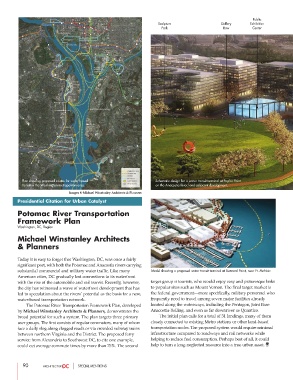
Plan showing proposed routes for water-based Schematic design for a water transit terminal at Poplar Point
transit in the Washington metropolitan area. on the Anacostia River, and adjacent development.
Images © Michael Winstanley Architects & Planners
Presidential Citation for Urban Catalyst
Potomac River Transportation
Framework Plan
Washington, DC, Region
Michael Winstanley Architects
& Planners
Today it is easy to forget that Washington, DC, was once a fairly
significant port, with both the Potomac and Anacostia rivers carrying
substantial commercial and military water traffic. Like many Model showing a proposed water transit terminal at Buzzard Point, near Ft. McNair.
American cities, DC gradually lost connections to its waterfront
with the rise of the automobile and rail transit. Recently, however, target group is tourists, who would enjoy easy and picturesque links
the city has witnessed a wave of waterfront development that has to popular sites such as Mount Vernon. The final target market is
led to speculation about the rivers’ potential as the basis for a new, the federal government—more specifically, military personnel who
water-based transportation network. frequently need to travel among seven major facilities already
The Potomac River Transportation Framework Plan, developed located along the waterways, including the Pentagon, Joint Base
by Michael Winstanley Architects & Planners, demonstrates the Anacostia-Bolling, and even as far downriver as Quantico.
broad potential for such a system. The plan targets three primary The initial plan calls for a total of 31 landings, many of them
user groups. The first consists of regular commuters, many of whom closely connected to existing Metro stations or other land-based
face a daily slog along clogged roads or via crowded subway trains transportation nodes. The proposed system would require minimal
between northern Virginia and the District. The proposed ferry infrastructure compared to roadways and rail networks while
service from Alexandria to Southwest DC, to cite one example, helping to reduce fuel consumption. Perhaps best of all, it could
could cut average commute times by more than 75%. The second help to turn a long-neglected resource into a true urban asset.
90 SPECIAL MENTIONS